ArkEdge Space will contribute to the ground station operation of the nano-satellite TIRSAT, which will be launched by the second H3 rocket test vehicle
The TIRSAT nano-satellite is scheduled to be launched on February 15, 2024 aboard the second test flight of Japan's new H3 launch vehicle, H3TF2, and will participate in the initial and regular operations using our Makinohara ground station and other facilities.
About TIRSAT
TIRSAT was selected by the Ministry of Economy, Trade and Industry (METI) for the "FY 2020 Supplemental Technology Development and Demonstration Project for Strengthening Supply Chains (Development and demonstration of a satellite-based situation monitoring system that contributes to rapid and flexible supply chain reconfiguration). The 3U size (12 cm x 12 cm x 38 cm) nano-satellite was developed by Seiren Corporation (Fukui City, Fukui Prefecture), the University of Fukui, the University of Tokyo, and the Nakasuka-Funase Laboratory, Department of Aerospace Engineering, Graduate School of Engineering, the University of Tokyo, under the auspices of the "Development and Demonstration of a Status Understanding System Using a Satellite to Contribute to Rapid and Flexible Recombination of the Supply Chain" project. The "Uncooled Small Thermal Infrared Sensor" onboard this satellite can observe the thermal infrared, and will be used for monitoring economic activities, such as investigating the operation of steel mills that emit a large amount of heat. It is expected to confirm its effectiveness as a means of gathering information in preparation for future crises.
ArkEdge Space has been supporting the development of the satellite's communication system, in addition to providing the receiver developed by MHI for use onboard the satellite.
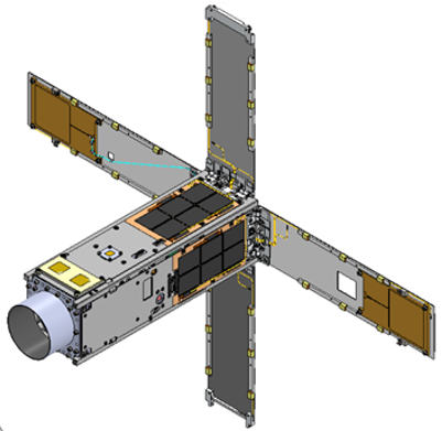
3U satellite TIRSAT
Contributing to TIRSAT ground station operations
After the launch of the second test model of the "H3 Launch Vehicle" scheduled for February 15, 2024 (Thursday), ArkEdge Space will conduct initial and regular operations of the TIRSAT satellite using our ground stations, mainly the Makinohara ground station (Shizuoka Prefecture)*. After the transition to regular operations, we plan to contribute to the reception and utilization of thermal infrared image data transmitted from the satellite on the ground.
TIRSAT ground station operation system
The TIRSAT satellite will be operated in cooperation with MHI, Seiren, the University of Fukui, and the Fukui Institute of Technology. After the satellite is injected into orbit, we will spend about two weeks ensuring communication between the satellite and the receiving station (critical operation) and checking the health of the satellite (initial operation). If there are no problems, the satellite will be put into regular operation and demonstration experiments of uncooled small thermal infrared sensors, etc. will be started.
About Our Makinohara Ground Station
A ground station (satellite control ground station) is a facility with antennas for transmitting signals necessary for satellite operations to space and for receiving and processing data transmitted from satellites to the ground. ArkEdge Space maintains our own ground station in Makinohara City, Shizuoka Prefecture, to facilitate flexible and efficient development and operation of our satellites. In addition to our own satellite control, we plan to provide ground station services for the purpose of developing and demonstrating satellites for other companies.
Outline of Makinohara Ground Station
Antenna height: 10m
Parabolic antenna diameter: 3.9m
Supported frequency bands (S-band up/down, X-band down only, Ka-band down only)
For remote satellite operations, the Makinohara Ground Station is connected to the Ariake Head Office with a leased high-speed digital circuit line.
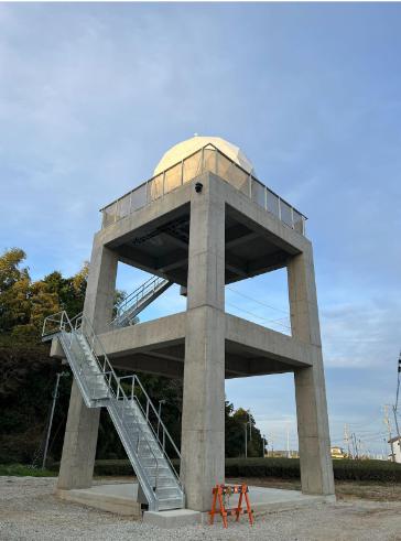
Makinohara Ground Station
About the Thermal InfraRed Sensor installed in TIRSAT
TIRSAT is equipped with an uncooled compact thermal infrared sensor developed by Vision Sensing Corporation, which can observe thermal infrared (Thermal InfraRed) to measure thermal changes on the ground surface and objects. In this on-orbit demonstration, the far-infrared region will be measured by this thermal infrared camera. (High sensitivity mode: 8-14μm band, Wavelength limited mode: 10.5-12μm band can be selected.)
By measuring the temperature distribution on the ground surface and sea surface with thermal infrared sensors, it is expected to be used for clarification of the heat island phenomenon, investigation of ocean current fluctuations such as the Kuroshio and Oyashio currents, forest fire detection, volcano monitoring, emergency photography of volcanic eruptions, and other applications. We will also consider applications in monitoring economic activities, such as investigating the operation of steel mills that radiate large amounts of heat. It is expected to confirm its effectiveness as a means of gathering information in preparation for future crises.
About ArkEdge Space, Inc.
ArkEdge Space Inc. is a venture company that provides a wide range of comprehensive solutions, from planning and design of the world's most advanced nano-satellite constellations to mass production and operation. The company's business fields are diverse and include the provision of solutions through satellite data utilization, the development and manufacture of nano-satellite related parts, components, and software, and the maintenance and operation of ground stations.
Aiming for "a future where anyone can do business with satellites," we will build a constellation of satellites for IoT communications, earth observation, and oceanic VDES, as well as a constellation of satellites for lunar activities and deep space exploration. In addition, we will promote the development and utilization of space that is accessible to all through a business model that meets all space needs.